Fantastic Læsø
Sky, Sea and endless horizons
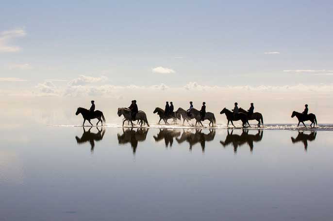
The Rønners is the protected area in which we ride the most, and it extends over approx. 1750 ha. The area is part of Natura 2000 and is owned by approx. 350 different landowners and grazed by cows and horses.
The description is inserted from www.fredninger.dk/fredning/roennenerne/
"Rønnere, which forms the southernmost part of Læsø, is green, flat and large, and the landscape is reminiscent in many ways of the marshlands in the Wadden Sea. However, the two are of very different origins; the tides, which have created the marsh, have virtually no significance in the Kattegat and thus neither for the formation and continued growth of the Rønner. In the northern Wadden Sea, the tidal difference is approx. 1½ m, around Læsø only 25-30 cm. Here, it is the wind direction and wind speeds that determine how high the water rises above the salt meadows.
Læsø is formed on Late Glacial deposits of clay, the so-called yoldials. It lies above most of the island at approximately sea level today. Over these clay layers, sand from the Stone Age sea was subsequently deposited, and with the help of land uplift, the layers have gradually appeared above sea level. Læsø is believed to have arisen for the first time approx. 5000 years ago to later be "drowned" again by the rising water level in the Stone Age Sea. Only 2-3000 years ago did Læsø appear again and eventually became the island we know.
Læsø is therefore completely an island created by the sea and, like the majority of Denmark, was not shaped by glacial movements during the ice age.
The formation of land started on the northern part of what is now Læsø, but today it is especially on the southern half that new land is created. In other words, the Rønns belong to the youngest parts of Læsø and were mainly formed within the last 800 years.
In most places on Læsø, land accretion has taken place by repeated deposition of shore-parallel seawalls. But while the seawalls in several places on the island can be 1-2 meters high and very clear, they are quite weakly marked in the terrain on Rønnerne. The beach erosion pattern can, however, be recognized in many places on the Rønnerne through the difference in the vegetation on the higher and lower surfaces.
The reason for the poor formation of seawalls is probably that the sea areas south of Læsø are so shallow that the waves do not contain sufficient energy for any significant material transport and deposition. It will thus be the land elevation that will have the main responsibility for land development on southern Læsø. On the other hand, it also has a nice speed of: 3-5 mm per year; Læsø is probably the locality in Denmark that has had the fastest land uplift since the Ice Age.
The word "Røn" means a rocky ground or a small uninhabited islet. The entire area consists of the 4 large fjords: Færøn, Kringelrøn and Langerøn, which are separated by narrow tidal channels, as well as Hornfiskrøn, which you have to cross a wider but also shallow belt to reach. There is also a larger number of small islets.
A large part of the approx. 1750 ha, over which the protected area extends, is flooded by the sea several times in the winter during storms. It is the sand and mud flats as well as the regular salt meadow areas that therefore have salt-tolerant vegetation. The parts that are not flooded with seawater appear as moorland or are planted with forest. Large parts of Langerøn are cultivated.
Although it is sand and gravel that is deposited by the sea and thus builds up the southern Læsø, large stones largely characterize the image of Rønnerne. They were brought here by the ice and dumped on the spot when the glaciers melted. In hundreds, they lie next to each other and give the eye something to hold on to on the endless surfaces. The stones were encased in the yoldial layer 12-14.000 years ago and were later washed free as the seabed rose."
The dune plantation When we are not riding on Rønnerne, the trip takes place to Læsø Klitplantage. The description is inserted from www.visitlaesoe.dk
"In the middle of the island and towards the northern coast is Læsø Klitplantage - an area with beautiful and varied nature and a rich wildlife. Here you will find both dense coniferous forest and extensive dunes, and in just a few kilometers you can move through several different types of beautiful landscapes.
Læsø Klitplantage is not very old. In the 1930s, the state began to plant areas with Scots pine and Sitka spruce. There are ample opportunities to experience how nature develops in such a young forest area. There used to be extensive pine forests on Læsø.”